



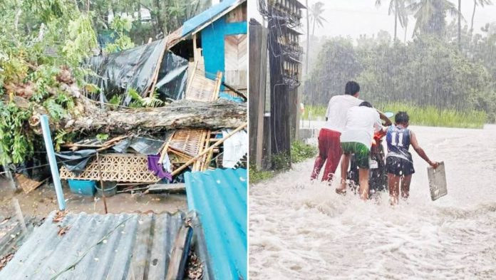
ILOILO – Typhoon “Tino” (international name: “Kalmaegi”) unleashed its full fury over Western Visayas on Tuesday, November 4, bringing destructive winds, rains, and coastal flooding that battered homes, uprooted trees, knocked out power lines, and interrupted internet connections.
Packing maximum sustained winds of 150 kilometers per hour and gusts reaching up to 205 kph, Tino’s howling winds and rains swept across the region as it moved west-northwest at 25 kph after making initial landfall in Silago, Southern Leyte early in the morning. The Philippine Atmospheric, Geophysical and Astronomical Services Administration (PAGASA) placed parts of Iloilo, Guimaras, Capiz, Antique, and southern Aklan under Signal No. 4 — its second-highest warning — signifying “very destructive typhoon-force winds.”
At around 7 a.m., the eye of Tino was tracked near Sagay City, Negros Occidental, according to Doppler radar readings from Iloilo and Masbate, its first landfall in Western Visayas. PAGASA warned that strong to typhoon-force winds extended up to 300 kilometers from the storm’s center, threatening widespread damage to infrastructure and agriculture.
Coastal Flooding, Power Cuts, and Evacuations
Storm surges as high as three meters battered coastal communities in Iloilo and Antique, forcing hundreds of families to flee their homes. Low-lying barangays in Guimaras and Capiz were threatened with submersion as rains swelled rivers and inundated roads.
Ahead of Tino’s Western Visayas landfall, Raul Fernandez, regional director of the Office of Civil Defense and chair of the Regional Disaster Risk Reduction and Management Council (RDRRMC), urged immediate evacuation from high-risk areas.
“We are advising immediate evacuation for all communities at risk. Evacuation centers should be established at least 500 meters inland from the coastline,” said Fernandez, warning that the storm surge threat could reach more than a kilometer inland — “almost like a tsunami event.”
By noon yesterday, pre-emptive evacuations were in full swing across the region as howling winds tore off rooftops and brought down trees and electric poles.
Ferry operations were suspended, while several highways became impassable due to flooding and fallen debris.
Communication disruptions were also reported as power and internet lines went down in several towns.
Heavy Rains and Landslide Threats
PAGASA meteorologist Jan Baron warned that rainfall totals could range from 50 to 504 millimeters from November 2 to 5 — enough to trigger widespread flooding and landslides, especially in mountain and hillside communities.
“The ground is already saturated from earlier rains,” Baron said. “The added volume from Tino increases the risk of landslides in vulnerable areas.”
Authorities ordered the clearing of clogged drainage systems and waterways as rain continued to pound Iloilo City and nearby towns.
Relief Operations in Full Gear
The Department of Social Welfare and Development (DSWD) prepositioned 93,864 family food packs across 55 sites in the region before the storm’s onslaught — 36,402 in Capiz, 30,316 in Iloilo, 17,350 in Antique, 8,559 in Aklan, and 1,237 in Guimaras.
DSWD disaster response head Claud Jan Marquez said distribution teams were working despite difficult conditions.
“It’s crucial that local authorities and community leaders remain coordinated to ensure that food and essential supplies reach those in need swiftly,” Marquez emphasized.
Over a Million Affected
Initial estimates placed the number of individuals affected at 1.43 million, including 97,433 poor families living in coastal and low-lying communities vulnerable to floods, strong winds, and landslides.
Iloilo on High Alert
Gov. Arthur Defensor Jr. convened the Provincial Civil Defense Cluster to coordinate disaster response.
“The safety of every Ilonggo remains our top priority,” he said, ordering local government units to activate emergency operations centers and prepare evacuation facilities.
Local disaster risk reduction and management offices were directed to mobilize response teams, provide temporary shelters, and ensure the availability of food, water, and medical assistance to displaced residents./PN