


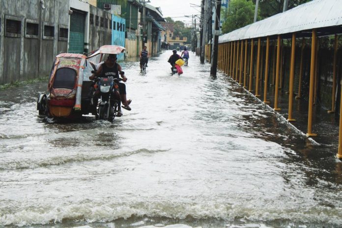
ILOILO City – This city’s existing drainage system can no longer handle the volume of water produced by intense rainfall, city engineers admitted after flooding swept through 65 barangays and affected 789 families or 2,529 individuals on Monday night, August 17.
City Engineer’s Office chief Engr. Mavi Gustilo said the widespread flooding exposed serious limitations in the city’s drainage infrastructure, with several outfalls submerged as swollen creeks prevented stormwater from flowing out of communities.
“Aton mga existing drainage dapat na gid i-upgrade kay indi na kasarang sang volume sang tama ka-baskog nga rainfall intensity,” Gustilo said. “Indi na gid sufficient.”
The Iloilo City Emergency Operations Center (EOC) reported floodwaters reaching as high as 50 inches in some areas, forcing hundreds of families to evacuate.
Barangay Sambag in Jaro district was among the worst-hit areas, with floodwaters reaching 36 to 50 inches.
Barangay Taft North in Mandurriao district and Barangay Our Lady of Lourdes in Jaro recorded water levels of up to 45 inches.
Floodwaters in Barangay Sta. Rosa, Mandurriao reached 30 to 37 inches, while Barangay Calubihan in Jaro and Barangay Bantud in La Paz district recorded levels of up to 37 inches.
As of 2 p.m. on August 18, floodwaters had subsided in 14 barangays, but 51 remained flooded, based on reports received from barangay officials and the City Disaster Risk Reduction and Management Office’s Barangay Disaster Risk Reduction and Management Services Division.
Gustilo said elevated water levels in creeks, including Dungon Creek, submerged outfalls connecting barangay drainage networks to major waterways.
“Ang level sang tubig sa creek nga ginalantaw ta is taas gid kaayo,” she said. “Ang ga-connect nga mga outfall sang aton mga barangay na-submerge na. Isa ka tendency, indi ka gwa dayon ang tubig nila.”
Water flowing from higher-elevation areas also placed pressure on downstream communities, added Gustilo.
Runoff from areas around Central Philippine University and Barangay Cuartero, Jaro moved toward lower portions of the city, contributing to flooding in Taytay Zone 2 and Calubihan, the city engineer said.
Aside from upgrading existing drainage lines, the City Engineer’s Office is considering dredging, slope protection, floodgates and pumping systems as possible interventions.
For Barangay Calubihan, Gustilo said floodgates could prevent swollen creeks from forcing water back into drainage networks.
“Sa Calubihan, Jaro ginalantaw ko we need slope protection kag ang aton nga mga outfall, kun submerged, dapat floodgate nga kun magsaka, ga-close,” she said. “Indi siya mag-backflow.”
However, closing floodgates would trap stormwater inside the drainage system, requiring pumps to discharge it, she added.
“Ma-pump out ta tubig pa-gwa,” Gustilo said, referring to waterways connected to the Iloilo River.
The city may also request the Department of Public Works and Highways to deploy another dredging machine to Barangay Calubihan, where some of the highest flood levels were recorded being a low-laying area.
Garbage, fallen trees and other debris have further restricted the flow of water through drainage lines and waterways, added Gustilo.
“Ang aton sa mga barangays, gapang-declog kay grabe ang basura. May mga kahoy pa nga dapat utdon,” she said.
In La Paz, declogging operations removed debris that had occupied almost half of a box culvert near the market and Rizal Street.
“Last week, almost half sang box culvert may mga lay-on na gid ya. Kagina nakita ta gid ya nga naubos na. Nami ang flow,” Gustilo said.
However, she said bridges, concrete structures, informal settlements and private developments constructed near outfalls and waterways were also impeding water flow.
Clearing operations and the relocation of informal settlers may be necessary in affected waterways, Gustilo added.
“Gina-preparahan man na subong para ma-relocate sila,” she said.
Despite the recurring flooding, Iloilo City still has no comprehensive drainage plan.
“Sa subong, ara pa lang sa feasibility study,” Gustilo said.
Hydrologic analysis and other technical data would be needed to design a drainage network capable of handling the increasing volume and intensity of rainfall, she stressed.
“Later on, syempre kuhaan na sang data para mag-design sang drainage nga maka-accommodate tanan,” she said.
Meanwhile, 13 evacuation centers were activated across the city. At least 462 families or 1,459 individuals were staying in evacuation centers, while 333 families or 1,081 individuals were displaced outside the facilities.
Mayor Raisa Treñas said the city activated its Community Kitchen and distributed food and non-food assistance to affected residents.
She urged residents in flood-prone communities to evacuate immediately when instructed by authorities.
“Palihog maghalong kag magsunod sa mga abiso sang city government, barangay kag responders. Kun kinahanglan mag-evacuate, indi na maghulat nga maglala pa ang sitwasyon,” she said.
“Our priority is the safety of every Ilonggo. Padayon kita sa pagbuligay kag pag-atipanay. Maghalong kita tanan,” Treñas added.
According to the Philippine Atmospheric Geophysical and Astronomical Services Administration (PAGASA), rains are expected to continue pouring across the western parts of the country for the rest of the week. This is because two low pressure areas (LPAs) draw in the southwest monsoon.
According to PAGASA’S advisory earlier on Tuesday, the two LPAs have high chances of developing into tropical depressions within the next 24 hours.
The first LPA (LPA 08f) was last located at 1,170 kilometers east of extreme northern Luzon, while the other second LPA (LPA 08g) was at 400 km west of Calayan, Cagayan.
The two LPAs are helping pull the habagat toward the country, which brings rains to the Philippines’ western sections.
A tropical depression is also being monitored east of the Philippines.
It is located more than 3,000 kilometers away and has no effect in the country for now./PN