


ANTIQUE – The Provincial Disaster Risk Reduction and Management Council (PDRRMC) has activated all municipal and barangay emergency operations centers (EOC) in the province in preparation for the landfall of Tropical Depression (TD) “Aghon,” this year’s first tropical cyclone.
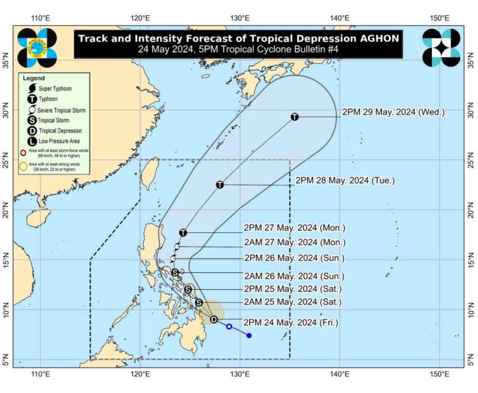
The Philippine Atmospheric, Geophysical and Astronomical Services Administration (PAGASA) said Aghon could make landfall over the southern portion of Eastern Samar or Dinagat Islands on Saturday morning as a tropical storm.
PDRRM Officer Broderick Train advised Antiqueños and EOCs near mountain slopes and low-lying and flood-prone areas to “take necessary precautionary measures to protect life and property.”
As of 5 p.m. yesterday, Tropical Cyclone Wind Signal No. 1 was hoisted over Eastern Samar, Samar, Northern Samar, Leyte, Southern Leyte, Biliran, Cebu (San Remigio, Tabogon, City of Bogo, Medellin, Daanbantayan, Borbon) including Camotes Islands, Bantayan Islands and Bohol (Pres. Carlos P. Garcia, Bien Unido, Trinidad, Anda, Candijay, Ubay, Mabini, Alicia, San Miguel, Talibon). Strong winds are possible in these areas.
Areas in Central Visayas and Quezon may be placed under Wind Signal No.1 in the next bulletin. The highest possible wind signal that may be hoisted during the passage of Aghon is Wind Signal No. 2.
As of 4 p.m. yesterday, PAGASA said the center of Aghon was estimated based on all available data at 135 kilometers (km) northeast of Hinatuan, Surigao del Sur or 185 km east southeast of Surigao City, Surigao del Norte.
Aghon was forecasted to move generally west northwestward to northwestward from Friday until today while slowly intensifying. Current forecast scenario showed intensification into a severe tropical storm by Sunday and into a typhoon by Monday.
Aghon is also forecast to bring moderate to rough seas over the coastal waters along the northern and eastern seaboards of Eastern Visayas, and the eastern seaboard of the Caraga Region.
PAGASA urged mariners of motorbancas and similarly-sized vessels to take precautionary measures while venturing into the sea and, if possible, avoid navigating in these conditions./PN