



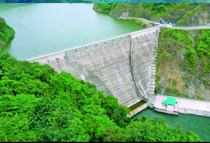
ILOILO City – Citing the more than 250 billion liters of water capable of being stored behind the 109-meter-high Jalaur High Dam in the mountains of Calinog, Iloilo, an environmental group is pressing authorities to publicly disclose dam safety data, downstream inundation maps and emergency protocols, warning that communities must be prepared for potentially catastrophic releases or other cascading hazards.
The Jalaur River for the People Movement (JRPM) said the catastrophic flooding in the Nepal-Tibet border region on Aug. 26 was a reminder of how extreme events in mountainous terrain could generate cascading hazards across interconnected river systems.
The reservoir in Calinog – deemed to be the biggest outside Luzon – is designed to hold about 250.7 million cubic meters of water, or more than 250 billion liters, behind the 109-meter-high structure in Iloilo’s mountainous watershed.
According to JRPM coordinator John Ian Alenciaga, the completion and impounding of the high dam under the Jalaur River Multi-Purpose Project Stage II (JRMP II) have fundamentally changed the risk landscape along the Jalaur River system, particularly for communities downstream.
The enormous volume of impounded water requires greater transparency on dam operations and stronger disaster preparedness among communities that could be affected by emergency water releases or a worst-case dam failure, he stressed.
“We are raising this warning so people can prepare,” Alenciaga said.
He said communities downstream should have access to information on the dam’s current water levels, operating rules, emergency procedures and areas potentially exposed to sudden water releases or dam failure.
“Those must be fully and publicly disclosed, along with geological and structural monitoring results and downstream inundation maps,” Alenciaga said.
The Jalaur River system is the second-longest river on Panay Island, stretching 123 kilometers through the province of Iloilo. It starts in the Central Panay Mountain Range near Mount Baloy, west of Calinog and flows east and southeast across Iloilo, passing through Passi City and towns including Calinog, Pototan, Dingle, and Dumangas. It empties into the Guimaras Strait.
MOUNTAIN WATERSHED RISKS
JRPM said a massive collapse of ice and rock in the Himalayas sent water, mud and debris rushing into river valleys in Nepal, damaging communities and infrastructure downstream.
Alenciaga clarified that JRPM was not suggesting that the same phenomenon would occur in Jalaur, but said the disaster underscored the speed with which hazards in mountainous watersheds could escalate.
Jalaur, according to JRPM, is a mountainous and interconnected river system exposed to typhoons, intense rainfall, landslides, erosion and earthquakes.
“With climate change altering rainfall patterns and increasing the possibility of extreme weather, these risks cannot simply be considered settled because the dam has been completed,” Alenciaga said.
The group also emphasized that disaster preparedness should not be limited to evacuation planning.
JRPM said the long-term safety of the reservoir is linked to the health of its watershed, where forest degradation, erosion, unstable slopes, sedimentation and poorly planned development could potentially aggravate risks.
It called for the participation of communities, farmers, indigenous peoples, local scientists and environmental organizations in monitoring the project and protecting the watershed.
INDEPENDENT RISK ASSESSMENT
JRPM called for an independent assessment of the dam and its surrounding watershed, covering threats from extreme rainfall, landslides, earthquakes, sedimentation and debris flows.
According to the group, the project’s Environmental Impact Statement itself identified concerns involving dam stability, earthquakes, typhoons, flash floods and climate change.
JRPM said areas along the Ulian and Alibunan rivers were also identified as vulnerable to flooding, landslides and erosion under dam-break or water-release scenarios.
Alenciaga stressed that the group is not claiming that a dam disaster is imminent, but said the potential consequences of an extreme event require authorities to prepare communities before an emergency develops.
“Communities living downstream must know the dam’s current water levels, operating rules, emergency procedures and areas that could be affected by sudden releases or dam failure,” he said.
JRPM said barangays potentially exposed to such hazards should have clearly identified evacuation routes and shelters, reliable warning and communication systems, and regular disaster drills.
Local governments and residents must likewise know which agency or authority would issue an emergency warning, how quickly information could reach threatened communities, and what residents should do once an alert is raised, the group said.
REASSESS DAM’S FUTURE
JRPM went further by calling for the long-term future of the Jalaur Mega Dam to remain subject to independent scientific scrutiny, including the possibility of decommissioning should evidence eventually show that its risks cannot be adequately managed.
“The long-term future of the Jalaur Mega Dam must remain open to serious and independent reassessment, including decommissioning or dismantling if scientific evidence establishes that its risks to communities and the environment cannot be adequately controlled,” Alenciaga said.
The group stressed that such reassessment should be based on scientific evidence and an independent evaluation of environmental and disaster risks.
“Disaster risk must be taken seriously before disaster occurs,” Alenciaga said. “The people of Calinog and downstream communities deserve transparency, preparedness and the right to participate in decisions that affect their river, their safety and their future.” (Rex J. Maestrecampo/PN)